Hi there!
Some notes from my Sunday afternoon walk in the Tauherenikau Valley.
Beginners mistake: Take your map out of your trousers' pockets when crossing a river. It might get wet or float away... mine got wet and wasn't laminated or in a plastic bag.
Good walking: Some more gavel came down the slips passing the lower track at Smith Creek SW of the Shelter. That provides good footing, the track is now easier than ever (let's see how long it stays like that).
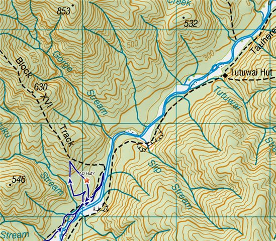
Allaway Dickson Hut Place: I made my way from Smith Creek along the block XVI track, turned left just after Kotukutuku Stream and bashed my way up straight North towards the nowadays Block XVI track (a good short cut) - very walkable bush. I looked at all sorts of clearings, nothing appealed to me as a former hut site e.g. less stones on the ground, trees of similar age, a gap in the canopy (younger trees), a chimney foundation - if it was made of stone or concrete. On the way down I kept more to the East (that is prolonging the bearing of the upper track, as the 'creators' of these blocks would have done), picked up a minor spur and finally stumbled across a roughly rectangular sunny patch with a fern tree in the middle and not much else but 3m high thin trees of the same age. I didn't find any stone foundations, just a bump of clay.
Significance to the club: This hut was built by VUWTC, finished 1949 and finally demolished in 1972 - read more here - well and a good excuse to get out into a beautiful valley on a sunny Sunday.
Now at home, I re-read the paragraph of a hut site description in the Tararua Footprints (1996) I'm pretty sure, I found the spot, as I crossed the small stream at the foot of the minor spur and the only bright spot I could make out in the otherwise shady and moist environment. The site must have been cut regularly till the re-routing of the Block XVI track.
So, these are the coordinates from my GPS:
(yes, I have a cheating device and use it - to read it out at home and find out how stupid I was when navigating without compass.)
NZTM 2000 Grid Reference NTopo50 PB33 940 564 or E1794042 N5456393
(WGS84) for the geo cachers: S41° 01' 14.1" E175° 18' 23.3"